Subdivision Presentations Draw Large Crowds, Raise Concerns
By BILL BELLEN
OTSEGO, SPRINGFIELD
The towns of Otsego and Springfield have been abuzz over the past week with the onset of two contentious town planning board meetings.
The matter at hand: A proposed 111-lot subdivision of 1,525 acres of properties on the west side of Otsego Lake owned by real estate developer Fraydun Manocherian.
The proposal’s 765 acres and 59 lots in the Town of Otsego and 760 acres and 52 lots in the Town of Springfield represent what was noted at the Otsego meeting to be the largest single property division in either town in decades.
Each planning board was presented with an in-depth sketch plan; a very early-stages display of the bare bones of what the proposed project would entail.
Town of Otsego
Otsego’s Planning Board meeting was held first, on Tuesday, August 5 at 7:30 p.m. Chairman Tom Huntsman made clear that it was not a public hearing, and that the Manocherian team was merely there to present what information they had. The Manocherian family was represented by Allyson Phillips of the Young/Sommer law firm, alongside Rob Aiello and James Caris from the site development consultants firm JMC. Phillips made remarks regarding the limited scope of information collected so far. She was followed by Aiello, taking the helm to present a slideshow of the sketch plan, which he agreed to share in an accessible manner after the meeting upon public request.
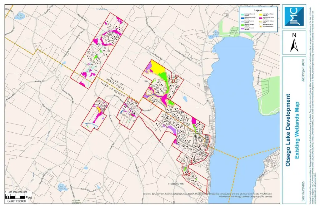
Aiello opened with overview maps of the properties, showing the proposed 111 lots with various filters over them, including the municipal boundary, proposed “neighborhoods” of development and zoning districts. All of the land in the Town of Otsego is in the RA1 (Residential Agriculture) District, while 12 properties in the Town of Springfield are in the Lake District, with the rest being in the town’s Residential Ag District.
Aiello highlighted the environmental surveying thus far, which indicated and demarcated all sensitive wetlands, streams and other environments. He confirmed these would be researched more heavily following the meeting and the beginning of the State Environmental Quality Review process. Using the information on hand, subdivision lines were drawn to avoid areas of incline greater than 15 percent and other environmental factors in order to mitigate environmental impact.
While viewing the existing wetlands map, Aiello shared, “We went through a layered analysis to understand the property better. We also worked with LaBella Associates. They went out and did a field delineation. They put [down] flags and they identified where there are wetlands, where there are streams, and where there are waterpurses.
“We worked with Quenzer Environmental, Aiello continued, “and they worked with us to help identify wildlife habitat and screen the property for any endangered or threatened species. In addition, we [worked] with Hartgen Archaeological Consultants, so they could do a phase 1A literature review…to understand the history of the site and to identify any historic resources.”
As Aiello presented each of the six proposed development areas individually, he made note of the applicant’s efforts to ensure the proposals were zoning compliant. He also acknowledged that a sense of scale was difficult to comprehend, given the large acreage of the project. Aiello’s presentation wrapped up with a final overview of the map, an overlay of emergency service and school district jurisdictions, and recognition that improvements may be required on a number of the existing roads within the project’s footprint.
The team then turned things over to the Planning Board for questions. Huntsman asked Phillips what her definition of residential agriculture was, to which she replied with the legal definition. Huntsman responded with an emphasis on the necessity for low-impact development in this definition.
“This is a rural area,” Huntsman said. “It’s historically a rural agricultural [region]. This is the largest subdivision in our area, and I’ve been doing this a long time.”
Huntsman then followed up with a detailed read through of the opening of the Town of Otsego’s Comprehensive Plan, which further underscored his point.
“The Manocherian family has owned this land since the 1960s,” Allison said. “It has not been farmed. They don’t have any intention of farming it. So we believe that a low-density residential development…does accord with those fundamental principles reflected in the comprehensive plan.”
Huntsman also shared his concerns over the condition of State Route 80, a road already in poor condition that would see a large increase in local traffic following the development of these lots. Phillips acknowledged the character of Route 80 and the other roads in the project’s footprint, and said an HOA may be created to maintain new roads if they remained private and were not dedicated to the town.
Other Planning Board members provided their input and questioned various aspects of the process, including the timeline of SEQR, clustering of developments and how plats will be filed. The Manocherian sketch plan portion of the meeting concluded with Huntsman saying that the board’s status as volunteers meant that the scale of this project was infeasible for review as one proposal. He acknowledged SEQR’s requirements for comprehensive review, but requested that the applicant attempt to address the varied geography, separated properties and the multitude of tax parcels by dividing the proposal into easier-to-address pieces.
Town of Springfield
As one meeting con-cluded, another was on the horizon. Springfield’s Planning Board meeting commenced at 7 p.m. on Thursday, August 7 to a full gymnasium at the Springfield Community Center. This presentation was headed by Phillips and Caris, and covered the same information as two nights prior, with a heavier emphasis on the wetlands located within the proposed project area, as 85 percent of them are located within the Town of Springfield.
Gretchen Sorin opened the board’s feedback strongly with, “This seems to me to be a suburban development, not a rural development…Is this like millionaires’ alley, or is it for rural families?”
Armstrong followed this up with concerns about the impacts of phosphorus runoff into the Otsego Lake watershed and the need to consult the SUNY Oneonta Biological Field Station, due to their specialties in understanding of local ecology. Phillips acknowledged these concerns and the project team’s responsibility—both legally and morally—to mitigate runoff and preserve the surrounding ecosystems.
Armstrong and Springfield Town Board Vice Chairman Denis Cimbal continued with a few more questions regarding traffic and potential plans to aid the town in covering the expenses of possible infrastructure improvements.
Board Chair Henry Miller pointed out that he had requested the short Environmental Assessment Form that the various firms involved in the sketch plan completed—in order to better understand what was environmentally at stake—and added that the board would be requesting a full EAF in order to begin the SEQR process.
Charlie Gottlieb, land use environmental attorney at Whiteman, Osterman & Hanna, then addressed the audience as special counsel to the Town of Springfield.
“There’s a few things we’re going to do tonight,” Gottlieb explained. “One is, we’re going to classify the project—likely as a major subdivision. Two, we are going to likely entertain retaining an engineering firm to represent the town, so that what the applicant provides us can be assessed by the town’s independent consultants.
“We are also going to start soon. The SEQR process is quite convoluted,” Gottlieb continued. “There is one agency that handles the environmental review process for the entire project. The agency that does that has to have some sort of permitting authority over the project. Here, it’s either going to be the Town of Springfield or the Town of Otsego.
“New York State town law says we have to complete the SEQR process before we can have a public hearing. Out of our hands, that’s just state law. There will maybe be potential for public input before the SEQR process is over, but we can address that in the coming months,” Gottlieb said.
Quickly following Gottlieb’s address, the board made a motion and approved the major subdivision classification. Gottlieb then discussed the prospect of being the lead agency in the SEQR process with the board, due to the Town of Springfield having more environmentally-fragile environments, something the board seemed to come to a consensus on pursuing.
“[With] 85 percent of the sensitive areas in our town, we have a responsibility to step up,” Miller said.
Gottlieb then recommended the engineering firm AKRF for the planning and environmental review. He also suggested creating an escrow account for the applicant to fund town-side measures of review. This prompted Miller to make a motion to create a rolling $10,000.00 escrow account that the applicant would be required to refill once it reaches $2,000.00 remaining, which the board subsequently approved.
Miller then went over his citations and recommendations based on his review of zoning compliance for the project. When the concept of a gated community was brought up, Gottlieb clarified it would not be possible if the newly-constructed roads were public. No representative from the Manocherian team mentioned the HOA discussed at the Town of Otsego meeting.
Following further deliberation, Miller opened the floor to public questions exclusively regarding the process to date and the SEQR process to come. Though the first audience member offered his name, this formality was quickly dropped in favor of more rapid-fire questioning. Members of the public questioned what being the lead agency entails, timing of the process, concerns over cooperation between Otsego and Springfield, and how the special counsel for the town was hired.
In response to accusations that the Springfield Planning Board was welcoming this proposal, Gottlieb rebuked, “This board, as a municipal land-use board, is under an obligation to review every application that comes before us. This is no different [than] if someone came in with a two-lot subdivision. They have to go through the process; they have to evaluate all the impacts. This board has a fiduciary duty to both the applicant and the community to see that process through.”
Public questions lasted just shy of 25 minutes. A number of queries could not be adequately addressed at this time, being that the proposal is still in the early stages of planning.
“Our website will have everything that you want to know, everything that is going on will be on it… What we’re doing, how we’re doing, all this kind of stuff,” Miller said. “There’ll be a calendar that will be constantly updated and—further down the line, as or if any of the plats change—all the plats will be on it.”
The Manocherian family and their representatives will be taking the feedback from both board meetings and making modifications to their plans in order to try and accommodate the suggestions made. Phillips and Gottlieb said further progress involving aspects such as the SEQR process will take several months.
Both planning boards committed to keeping their constituents in the know and will maintain communication regarding any future public meetings on the matter.